WisDOT Civil 3D coordinate system action summary
Last updated: 2026-01-06
The WisDOT coordinate projection zone category which was in use through Civil 3D 2016 and 2018 has been retired and is no longer needed in Civil 3D 2020 and beyond.
Coordinate systems in Civil 3D should only be applied when a projection transformation is needed.
Projections for Civil 3D 2020 and beyond should be selected from the Zone Category: USA, Wisconsin. WISCRS projections begin with NSRS2011 Wisconsin County CRS
Projections for Civil 3D 2016 and 2018 should be selected from the Zone Category: WisDOT.
 Introduction
In late 2016 it was discovered that project survey data was being transformed when coordinate systems were not being used uniformly throughout a Civil 3D project. This transformation occurs when the coordinate system selected for a LandXML import differs from the coordinate system assignment for a survey database. The transformation also occurs when data from a survey database is inserted into a dwg file that has a coordinate system assignment different from the survey database. For more information on the issue and what can be done to identify and resolve the issue refer the following C3DKB topics:
The WisDOT Methods Development Unit and Surveying and Mapping Section has coordinated with Autodesk to identify the source of the unintended transformations. The source of the unintended transformations depends on the coordinate systems that are selected.
Issue #1
Civil 3D is shipped with a coordinate system category called "USA, Wisconsin". This category of coordinate systems includes two series of Wisconsin County coordinate systems. Examples:
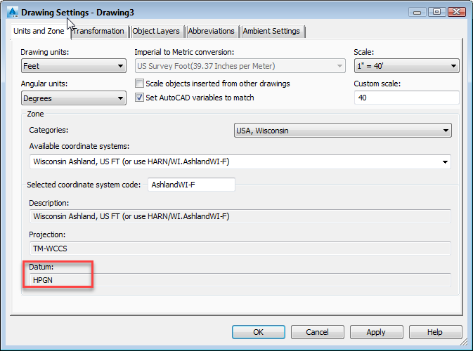
Figure 1: Original Civil 3D prepackaged coordinate systems used HPGN datum (NAD 83/1991)
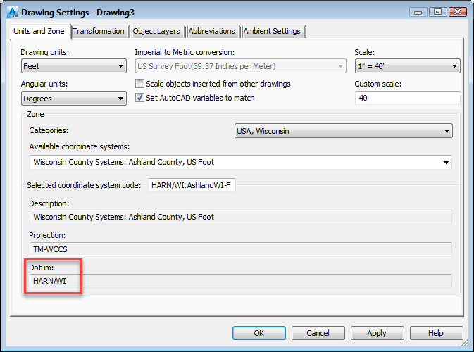
Figure 2: Autodesk later introduced coordinate systems that use state-specific HARN datums (NAD 83/1991)
While these two systems have different datum assignments (HPGN vs HARN/WI), the two datums are equivalent, both based on NAD83(1991), and only differ by name. However, it was discovered that the transformation definitions into and out of these two datums are not equivalent in Civil 3D. In the example above, the transformation definition into and out of the "Wisconsin Ashland, US FT (or use HARN/WI.AshlandWI-F)" is based on a series of grid files for every state. Civil 3D processes the grid files in an order defined by the transformation definition. Since the grid files overlap, and the Wisconsin grid file is near the bottom of the list, the transformations often occur based on another states grid file. Therefore, this transformation definition is not correct. For the "Wisconsin County Systems: Ashland County, US Foot" example, the transformation definition is correctly defined by a single grid file specific to Wisconsin.
Issue #2
In 2016, WisDOT deployed its own set of coordinate systems in Civil 3D. These systems are organized in categories that begin with "WisDOT". Within these categories, there are two county systems, "WCCS" and "WisCRS". Each of these coordinate systems, regardless of which "WisDOT" category they fall into, are defined by the Civil 3D NAD83 datum. The NAD83 datum in Civil 3D is based on the 1986 adjustment year.
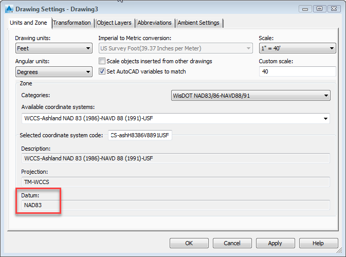
Figure 3: In 2016, WisDOT introduced coordinate systems using the Civil 3D NAD83 datum (NAD 83/1986)
Since the coordinate systems located in the "USA, Wisconsin" category use Civil 3D datums based on the 1991 adjustment year of NAD 83 and the coordinate systems that WisDOT provided in the "WisDOT..." categories are based on the 1986 adjustment year of NAD 83, a transformation occurs when moving data between these systems.
End-user prevention of unintended transformations
WisDOT recommends that project teams immediately stop assigning a coordinate system to the survey database and associated LandXML files. The absence of a coordinate system assignment will assure that an unintended transformation does not occur in dwg files receiving the survey data. Dwg files can still have a coordinate system assignment without the risk of an unintended transformation.
Action taken by WisDOT to prevent unintended transformations
Action #1: Modify Civil 3D transformation definitions
This action addresses Issue #1, the incorrect transformation between the two County systems provided in the USA, Wisconsin category of Civil 3D. To accomplish this, the "NAD83_to_HPGN transformation definition in Civil 3D has been modified so the Wisconsin grid file is moved to the top of the list and therefore processed first.
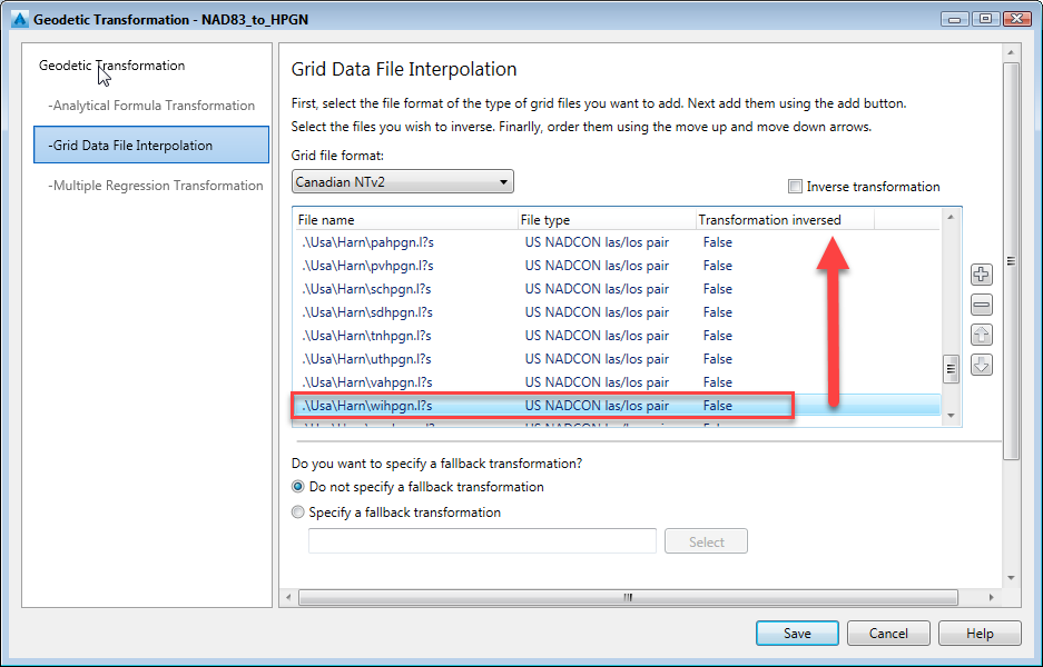
Figure 4: Grid files are processed based on the order shown in the Geodetic Transformation
Action #2: Set all "WisDOT" coordinate systems to the HARN/WI datum
By setting the "WisDOT" coordinate systems to use the HARN/WI datum in Civil 3D, it will assure they match the Wisconsin County coordinate systems included in the USA, Wisconsin category. Unintended transformations would no longer occur between the WisDOT coordinate systems and the USA, Wisconsin coordinate systems because they would have the same datum.
Action #3: Eliminate the current WisDOT coordinate system naming convention
The naming convention deployed in 2016 for the WisDOT coordinate systems was designed so that the adjustment year of the collected survey could be documented in the dwg file.
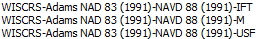
Figure 5: 2016 WisDOT coordinate system naming convention includes adjustment year as metadata
WisDOT has removed that metadata from the name and provided a single set of coordinate systems based on NAD 83 (1991), building upon Action #2. All names indicate that the coordinate system is based on NAD 83 (1991), so there is no uncertainty for the user.
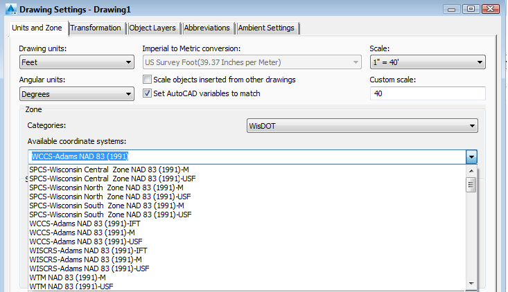
Figure 6: Sample WisDOT coordinate system naming and structure
Action #4: Remove FDM 19-10-43.4.1 requirement to assign coordinate system to all dwg files
FDM 19-10-43.4.1 states that "The coordinate projection used for the project shall be set on all DWGs." This requirement has been removed. This will lessen the likelihood of unintended transformations of data. However, users still have the option to assign a coordinate system to dwg files. There are situations where that needs to be done, such as for the Bing Map functionality in Civil 3D.
Frequently asked questions
Should I remove or change the coordinate system assigned to my DWG files?
This is not necessary. The old "2016 version" of the WisDOT coordinate systems is still present in the WisDOT customization files. They have been modified to use the HARN/WI datum to match the coordinate systems in the "USA Wisconsin" category. Moving forward, please use the coordinate systems under the "WisDOT" category located at the bottom of the Categories list.
Where did the old "2016 version" of the WisDOT coordinate systems go?
They are not located in the "Obsolete Coordinate Systems" category so they are present for legacy data. Moving forward, please discontinue using these coordinate sytems.