MarshExc - Version 26.0
Last updated: 2026-01-06
 Description
Inserts marsh excavation links from a defined target surface (MARSH) up to a separate target surface (EXIST) based on WisDOT standards.
Behavior
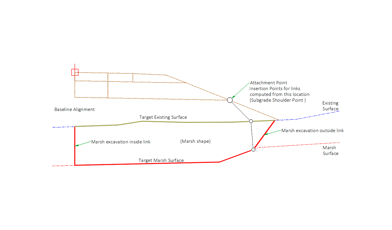
Inserts points and links that represent the area of marsh excavation. Three different scenarios may be encountered.
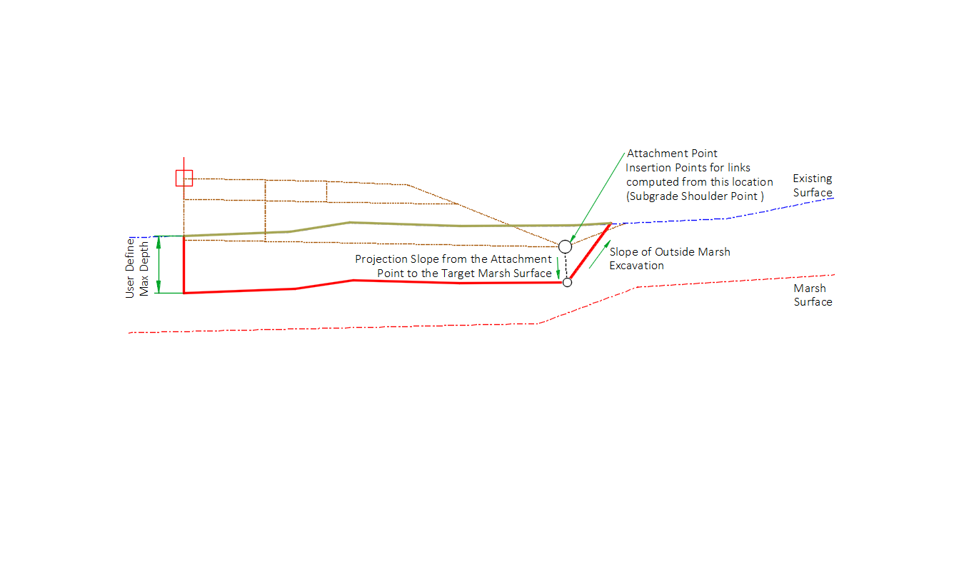
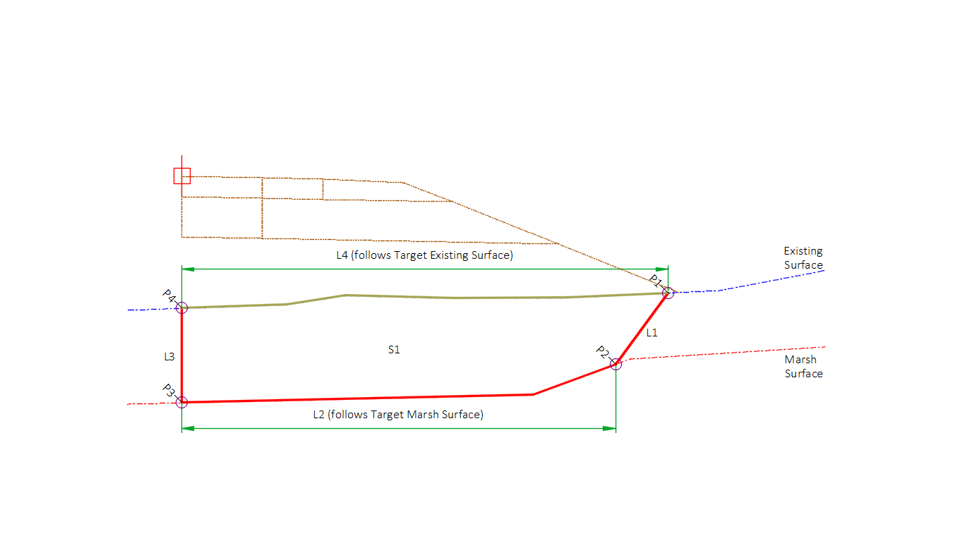
When attachment point is above Target Existing Surface
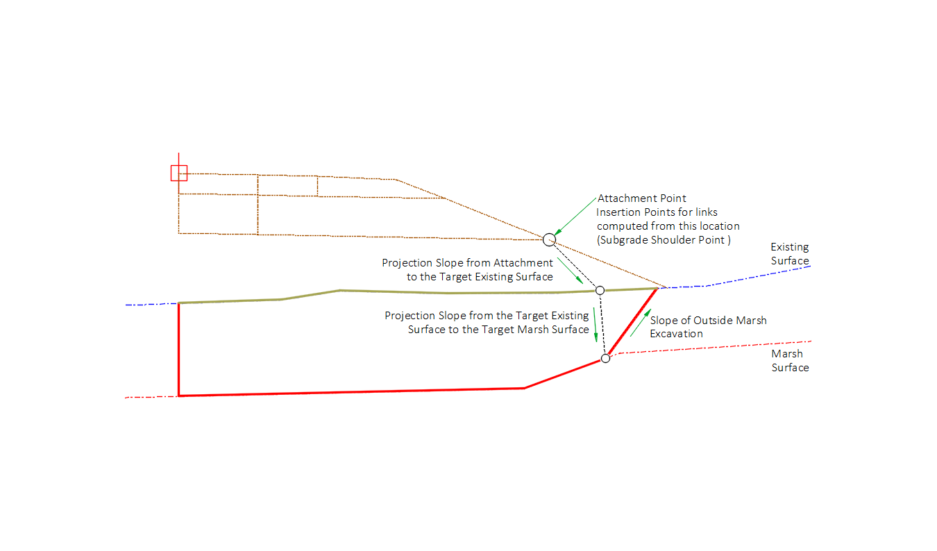
The subassembly will project from the attachment point down to the intersection with Target Existing Surface at a slope defined by the Projection Slope to Existing Surface input parameter. From this point, the subassembly will project down to the intersection of Target Marsh Surface at a slope defined by the Projection Slope to Marsh Surface input parameter. From this second projection point, an Outside Marsh Excavation link is inserted, projecting back up to Target Existing Surface using the Outside Marsh Excavation Slope input parameter.
Three additional links are inserted: (L3) the Marsh Excavation Inside Link starts on the Target Existing Surface at an offset from the baseline based on the Inside Marsh Excavation Offset input parameter and extends vertically to the intersection with Target Marsh Surface. (L4) A set of links that follows the Target Existing Surface from the Marsh Excavation Inside Link to the Marsh Excavation Outside. (L2) A set of links that follows the Target Marsh Surface from the Marsh Excavation Inside Link to the Marsh Excavation Outside Link.
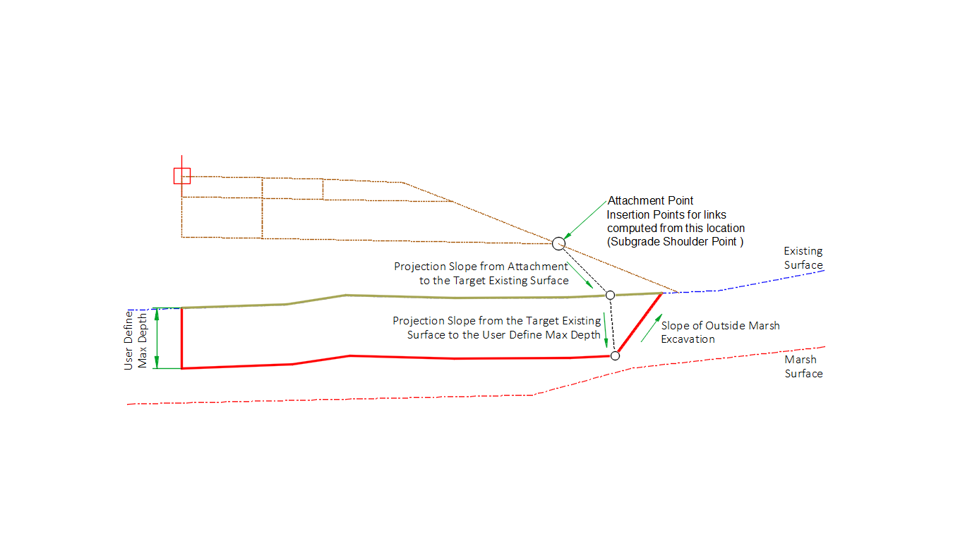
If the User Define Max Depth input parameter is greater than 0 than the link is inserted downward from the Target Existing Surface location determined by the Projection Slope from Attachment link, until it reaches the Max Depth. The bottom set of links is created than follows the User Define Max Depth value from the Marsh Excavation Inside Link to the Marsh Excavation Outside Link.
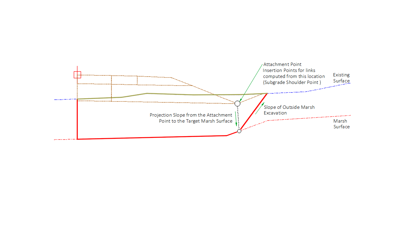
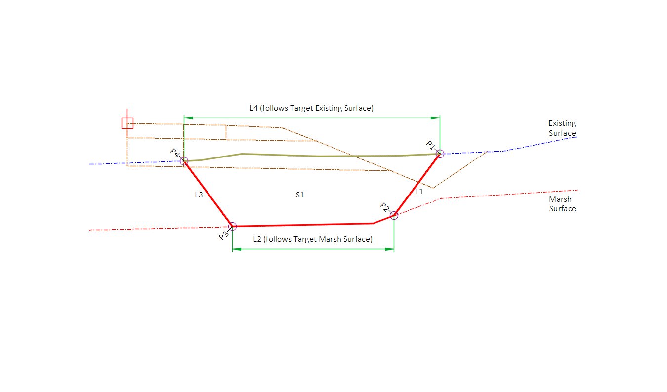
When attachment point is below Target Existing Surface
The subassembly will project from the attachment point down to the intersection with Target Existing Surface at a slope defined by the Projection Slope to Marsh Surface input parameter. From this projection point, an Outside Marsh Excavation link is inserted, projecting back up to Target Existing Surface using the Outside Marsh Excavation Slope input parameter.
Three additional links are inserted: (L3) the Marsh Excavation Inside Link starts on the Target Existing Surface at an offset from the baseline based on the Inside Marsh Excavation Offset input parameter and extends vertically to the intersection with Target Marsh Surface. (L4) A set of links that follows the Target Existing Surface from the Marsh Excavation Inside Link to the Marsh Excavation Outside. (L2) A set of links that follows the Target Marsh Surface from the Marsh Excavation Inside Link to the Marsh Excavation Outside Link.
If the User Define Max Depth input parameter is greater than 0 than the link is inserted downward from the Attachment Point until it reaches the Max Depth. The bottom set of links is created than follows the User Define Max Depth value from the Marsh Excavation Inside Link to the Marsh Excavation Outside Link.
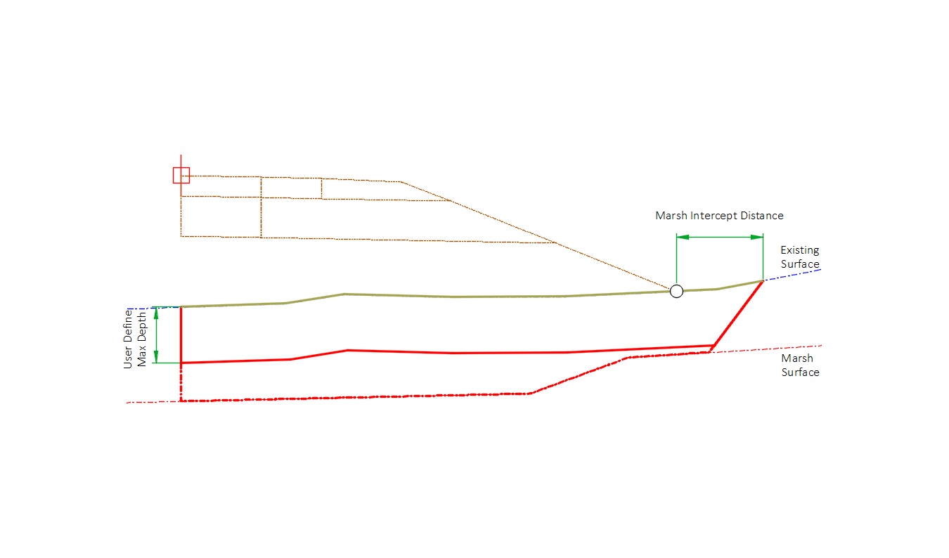
When using the Marsh Depth Table
The first step required to use the Marsh Depth Tables is to add a Mark Point at the slope intercept point of the daylight link. This will require that the Mark Point be added to the Daylight subassembly and be above the MarshExc subassembly in the assembly construction list. The Mark Point name needs to be the same as the name provide in the Mark Point Name input parameter.
The Marsh Depth Table can be used to determine the location of the Marsh Excavation intercept location on the Target Existing Surface. This is a distance, measured outward from the Mark Point, where the marsh excavation link will intercept Target Existing Surface. To determine this distance, the maximum depth between Target Existing Surface and Target Marsh Surface is computed between depths measured at the Baseline, the Max Depth Calc Inner Offset**,** the Max Depth Calc Outer Offset, and the Attachment Point. Once the maximum depth value has been determined, the parameter defining the marsh intercept distance value is determined, based on parameters set for Marsh Intercept Distance Value with Max Depth 0-10', Marsh Intercept Distance Value with Max Depth 10-14', etc. If the determined depth is greater than 30', the Marsh Intercept Distance Value with Max Depth 0-10' will be used. The User Defined Marsh Intercept Distance can be used to override the use of the Marsh Depth Table and to also set the offset distance when the depth is greater than 30’. A target option may be used to override this marsh intercept distance value assignment by assigning the Target marsh intercept offset.
Once the Marsh Intercept location on Target Existing Surface has been determined, a link is inserted downward until it intercepts Target Marsh Surface, using the slope specified.
Three additional links are inserted: (L3) the Marsh Excavation Inside Link starts on the Target Existing Surface at an offset from the baseline based on the Inside Marsh Excavation Offset input parameter and extends vertically to the intersection with Target Marsh Surface. (L4) A set of links that follows the Target Existing Surface from the Marsh Excavation Inside Link to the Marsh Excavation Outside. (L2) A set of links that follows the Target Marsh Surface from the Marsh Excavation Inside Link to the Marsh Excavation Outside Link.
If the User Define Max Depth input parameter is greater than 0 than the link is inserted downward from the Marsh Intercept location until it reaches the Max Depth.
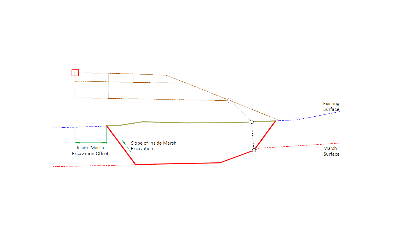
The Marsh Excavation Offset input parameter
Setting the Inside Marsh Excavation Offset input parameter value greater than 0 will set the Marsh Excavation Inside link to the offset value from the baseline on the Target Existing Surface at a slope equal to the Inside marsh excavation slope input parameter. This parameter creates the offset of the Marsh Excavation Inside link whether the attachment point is above or below the Target Surface Existing. The Inside Marsh Excavation Offset can be overridden by assigning a target object to the Target Inside Marsh Offset.
Attachment point is above the Target Existing Surface
Attachment point is below the Target Existing Surface

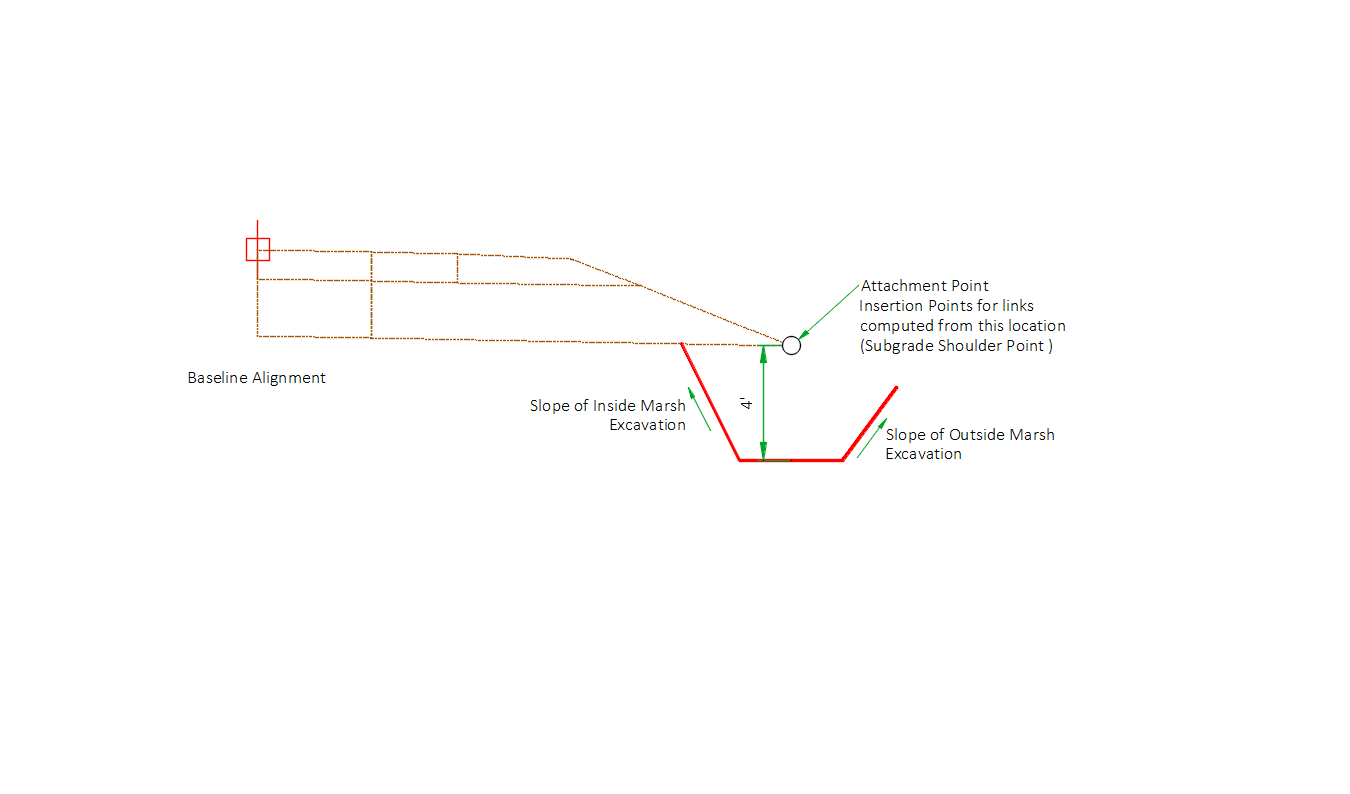
Attachment & layout mode operation
The Subassembly should be inserted at the Subgrade shoulder point for calculations to be performed properly. In layout mode, this subassembly displays links projecting from a point 4 feet below the attachment point using the slopes defined.
Input parameters
Info: All dimensions are in feet unless otherwise noted. All slopes are in run-over-rise form (for example, 4:1) unless indicated as a percent slope with a "%" sign.
| Parameter | Description | Type | Default |
|---|---|---|---|
| Side | Specifies which side to place the subassembly. | Left/Right | Right |
| Projection slope to existing surface | Specifies the slope of a line projected down from the attachment point to the intersection with the existing surface. No links are inserted. If the attachment point elevation is below the surface defined for Target Surface 1, this step is skipped. | Slope, Positive | 1:1 |
| Projection slope to marsh surface | Specifies the slope of a line projected down from the intersection point defined by the projection slope to existing surface to the intersection with the Marsh surface. No links are inserted. | Slope, Positive | 0.25:1 |
| Outside marsh excavation slope | Specifies the slope of the link inserted from the point on the marsh surface defined by the projection to marsh slope to the existing surface. | Slope, Positive | 1:1 |
| Inside marsh excavation slope | Downward slope of the Marsh Excavation Inside Link which runs from Target Existing Surface to the intersection with Target Marsh Surface at a distance from the baseline determined by the Inside Marsh Excavation Offset value. | Slope, Positive | 0.10:1 |
| Inside marsh excavation offset | Offset from the Baseline defining the location of the Marsh Excavation Inside Link starting on the Target Existing Surface. | Numeric | 0 |
| User define max depth | Defines the max depth of the marsh excavation calculated from the Target Existing Surface. If the value is set to 0 than the max depth function is not used and the depth is determined by the Target Marsh Surface. | Numeric | 0 |
| Use marsh depth tables | Setting the value to Yes specifies whether a computed value from the Marsh depth table input parameters is used or the user defined marsh intercept distance is used. If the user defined marsh intercept distance is set to greater than 0 than that value is used instead of the computed table values. | Yes/No | No |
| User defined marsh intercept distance | Fixed distance from attachment point used to determine the marsh excavation intercept location. | Numeric | 0 |
| Marsh intercept distance - max depth 0-10' | Distance from the mark point to the marsh excavation intercept location when the maximum marsh depth between the defined offsets is between 0 and 10 feet. The maximum marsh depth is calculated by determining the maximum depth from depths at the baseline, the attachment point, the Max depth calc inner offset location and the Max depth calc outer offset location. | Numeric | 0 |
| Marsh intercept distance - max depth 10-14' | Distance from the attachment point to the marsh excavation intercept location when the maximum marsh depth between the defined offsets is greater than 10 feet and less than or equal to 14 feet. | Numeric | 2 |
| Marsh intercept distance - max depth 14-18' | Distance from the attachment point to the marsh excavation intercept location when the maximum marsh depth between the defined offsets is greater than 14 feet and less than or equal to 18 feet. | Numeric | 4 |
| Marsh intercept distance - max depth 15-22' | Distance from the attachment point to the marsh excavation intercept location when the maximum marsh depth between the defined offsets is greater than 15 feet and less than or equal to 22 feet. | Numeric | 6 |
| Marsh intercept distance - max depth 22-26' | Distance from the attachment point to the marsh excavation intercept location when the maximum marsh depth between the defined offsets is greater than 22 feet and less than or equal to 26 feet. | Numeric | 8 |
| Marsh intercept distance - max depth 26-30' | Distance from the attachment point to the marsh excavation intercept location when the maximum marsh depth between the defined offsets is greater than 26 feet and less than or equal to 30 feet. | Numeric | 10 |
| Mark point name | A mark point is required to use the marsh depth tables. A mark point needs to be placed at the daylight intercept point of the daylight subassembly. A mark point name is used to find the mark point placed at this location, | String | MP1 |
| Max depth calc inner offset | Inside offset from the baseline where the depth is calculated between the Target Existing Surface and Target Marsh Surface. | Numeric | 10 |
| Max depth calc outer offset | Outside offset from the baseline where the depth is calculated between the Target Existing Surface and Target Marsh Surface. | Numeric | 20 |
| Right point suffix | List of options to use for adding a suffix to all point codes on the right side. The user defined option uses the value of the “Right user defined point suffix” parameter. | String, Combo List of Options: UserDefined _R NoSuffix PointCodeNumber | NoSuffix |
| Left point suffix | List of options to use for adding a suffix to all point codes on the left side. The user defined option uses the value of the “Left user defined point suffix” parameter. | String, Combo List of Options: UserDefined _L NoSuffix PointCodeNumber | NoSuffix |
| Right user defined point suffix | User defined right point code suffix | String | |
| Left user defined point suffix | User defined left point code suffix | String |
Target parameters
This section lists the parameters in this subassembly that can be mapped to one or more target objects, such as a surface, alignment, or profile object in a drawing.
| Parameter | Description | Status |
|---|---|---|
| Target existing surface | Name of the Surface representing the existing terrain. The following object types can be used as targets for specifying the surface: surfaces. | Required |
| Target marsh surface | Name of the Surface representing the Marsh layer. The following object types can be used as targets for specifying the surface: surfaces. | Required |
| Target inside marsh offset | Object used to define the offset for the beginning point of the Marsh Excavation Inside Link on Target Existing Surface. The following object types can be used as targets for specifying the offset: alignments, polylines, feature lines, or survey features. | Optional |
| Target marsh intercept offset | Object used to define the offset for the Marsh Intercept Distance on Target Existing Surface. The following object types can be used as targets for specifying the offset: alignments, polylines, feature lines, or survey features. | Optional |
| Target inner max depth offset | Object used to define the offset for the Max Depth Calc Inner Offset. The following object types can be used as targets for specifying the offset: alignments, polylines, feature lines, or survey features. | Optional |
| Target outer max depth offset | Object used to define the offset for the Max Depth Calc Outer Offset. The following object types can be used as targets for specifying the offset: alignments, polylines, feature lines, or survey features. | Optional |
Output parameters
| Parameter | Description | Type |
|---|---|---|
| MarshMaxDepth | Marsh max depth value | Required |
Coding diagram
When attachment point is above Target Existing surface
When attachment point is below Target Existing surface
Point, Link, and Shape codes
| Point/Link/Shape | Codes | Description |
|---|---|---|
| P1 | Marsh_Daylight_Out | Marsh excavation daylight point |
| P2 | Marsh_Bottom_Out | Marsh bottom outside point |
| P3 | Marsh_Daylight_In | Marsh bottom inside point |
| P4 | Marsh_Bottom_In | Marsh excavation inside point |
| L1 | MarshExc_Bottom | Marsh excavation outside link |
| L2 | MarshExc_Bottom | Marsh surface link |
| L3 | MarshExc_Bottom | Marsh excavation inside link |
| L4 | MarshExc_Top | Existing surface link |
| S1 | MarshExc | Marsh Excavation shape defined by links L1, L2, L3 and L4 |