Reports - Station-Offset-Elevation
Last updated: 2026-01-06
Overview
This script creates an .xlsx report of station, offset, and elevation from a baseline alignment on a surface or surfaces.
Usage
WisDOT Survey tab > Survey panel > Reports menu > Station-Offset-Elevation
The report can also be accessed from the command line: DOTREPORTSOE.
-
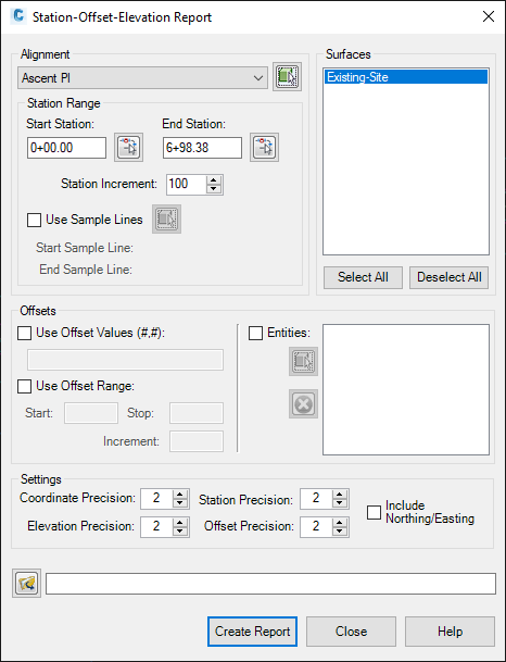
Alignment:
-
Select the baseline alignment from the menu or use the button to select the alignment from the drawing.
-
-
Station Range:
-
Either enter the start and end stations or use the buttons to select the stations from the drawing, then enter the station increment.
-
Or check the Use Sample Lines box to use sample lines instead of stations and increment, then use the button to select the start and end sample lines.
-
-
Surfaces:
-
Choose one or more surfaces to include in the report. Use Shift or Ctrl buttons to select multiple surfaces.
-
-
Offsets:There are 3 options. Check one or more to include in the report input.
-
Use Offset Values
-
Enter left and right values separated by a comma.
-
-
Use Offset Range
-
Enter Start, Stop, and Increment values.
-
-
Entities
-
Use the select button to select one or more alignment, feature line or polyline from the drawing
-
Use the delete button to remove objects from the list.
-
-
Settings:
-
Enter precision values and optionally check the Include Northing/Easting box.
-
-
Click the folder icon to open the Save File As.. dialog.
-
Create Report
-
The report will auto-open in Excel.
-
Save the report.
Sample report