Reports - Course Table
Last updated: 2026-02-24
Overview
This report will create a .xlsx file of a course of points and arcs with an optional closure report.
Usage
WisDOT Survey tab > Survey panel > Reports menu > Course Table
The report can also be accessed from the command line: DOTREPORTCOURSETABLE.
-
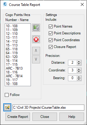
COGO Points/Arcs:
- Use the select button to select the desired COGO points and Arcs for the course. The points and arcs will be listed in the order they were selected. The course must begin and end with COGO points. All Arc ends must be coincident with a COGO point.
- Use the remove button to remove points/arcs from the list.
- Use the Up and Down arrow buttons to reorder the points/arcs in the correct course order.
- When the Follow check box is selected, the selected point/arc in list will be highlighted and centered in model space.
- Content:
- Project ID, Sheet No., and Traverse need to be filled in for a RWGIS export file. These values will be used to create the file name.
- By default, the course table report will include the point coordinates and bearings/distances between points, and arc lengths/radii along the course. Check the appropriate boxes to include point names, descriptions, and coordinates.
- Check Closure Report to include a closure report for the course.
- Select the desired precision settings for the report.
- Click the folder icon to Save Report As.. Select a file location and name. Save
- Click Create Report
- The report will auto-open in Excel.
- The Excel report includes 2 tabs.
- Course tab: This tab includes the course and closure report formatted as required for WisDOT GIS import.
ForSheet tab: This tab references the "Course" tab, but formats the information for incorporation on a plat sheet. A named range for the table called DL_CourseTable is also generated. This can be used to create a AutoCAD Data Link and Table in Civil 3D.
Sample report