WisDOT's development of their Construction Data Packet
IHEEP 2024
Last updated: 2026-01-06
IHEEP Conference 2024 Des Moines, Iowa
Steve Popke - WisDOT
Eric Gates - EnvisionCAD
September 17, 2024
Data Delivery
Before Civil 3D requirement
- Contractor Staking Packet
- Field Control
- Existing DTM
- Existing Topo and Utilities
- Reference Line
- Design Profile
- Superelevation
- Cross Section Slope Stake Report
-
Right-of-Way Monumentation
No design surfaces
Surface Models
One of the goals of Civil 3D implementation
- Facilitate better communication between engineers, contractors and stakeholders
-
Fully support Automated Machine Guidance construction activities
Contractor Outreach
Communication is required
- Obtain feedback on digital deliverables
- What surface elements are needed?
- Surface model detail
-
Design effort vs Construction benefit
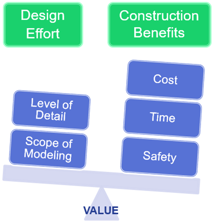
Outreach Insights
Pre-bid benefits
- Communicate design intent in 3D through the existing and proposed surfaces
- Readily analyze and confirm the project quantities
- Construction operations and operational alternatives can be planned and optimized to a much greater level of detail
Construction activity benefits
-
Design surface breaklines are key
- Provide the building blocks for construction model surfaces
- Organize to develop staging models based on contractor operations
- Supplement to provide additional surface model detail
-
Direct import of design data into survey equipment
Digital Data Delivery
Today
-
Construction Data Packet (CDP)
- A collection of electronic design files and data that has been exported from Civil 3D
- Digital data is provided in common file formats
- Available to contractors at project advertisement
For Information Only
It is only provided for the contractor’s general knowledge and is not a part of the construction project contract
Project requirements
- Provided on all WisDOT state trunk highway projects with a geospatially accurate reference alignment
- Data required for a project is dependent on project scope
- Not required on Local program projects but can be submitted
Construction Data Packet (CDP)
Metadata form
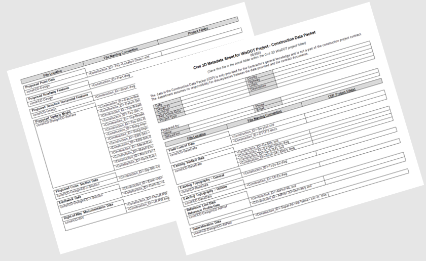
Existing condition deliverables
- Field Control Data
- Existing 3D Surface Model
- Existing terrain
- Rock
- Existing Topography – General
- Existing Topography – 2D Utilities
Proposed geometry deliverables
- Alignments
- Profiles
- Superelevation data
- Layout points
- Roadway features
- Structure horizontal features
Proposed surface model deliverables
-
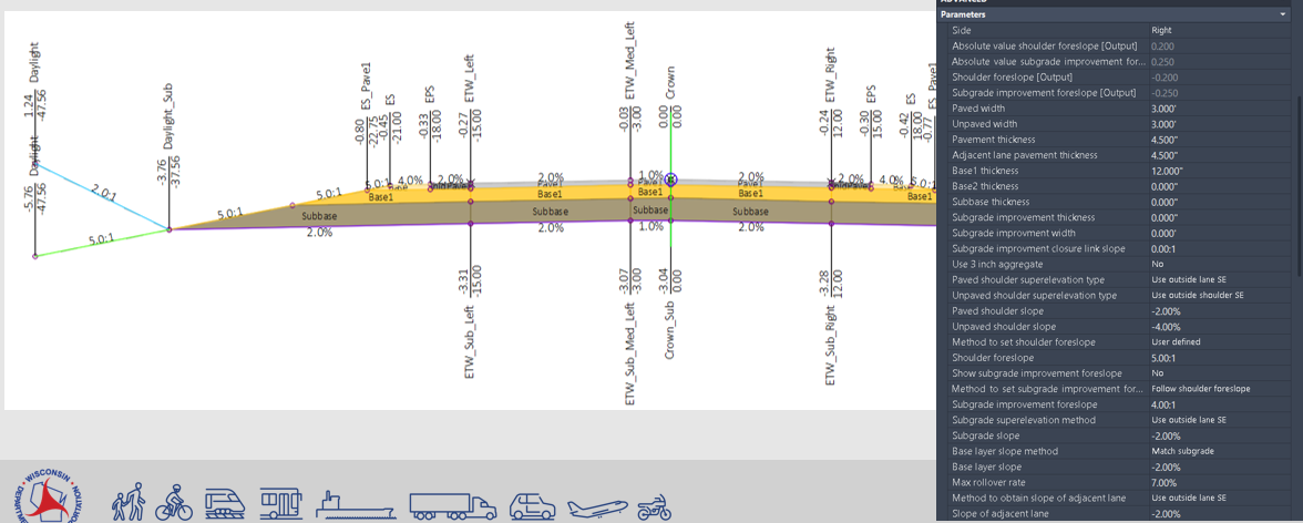
Breaklines, DTM, Boundary
- Top
- Datum (Subgrade)
- Top rural driveways
- Subgrade Improvement
-
DTM, Boundary
- Excavation Below Subgrade (EBS)
- Marsh excavation
- Rock excavation
-
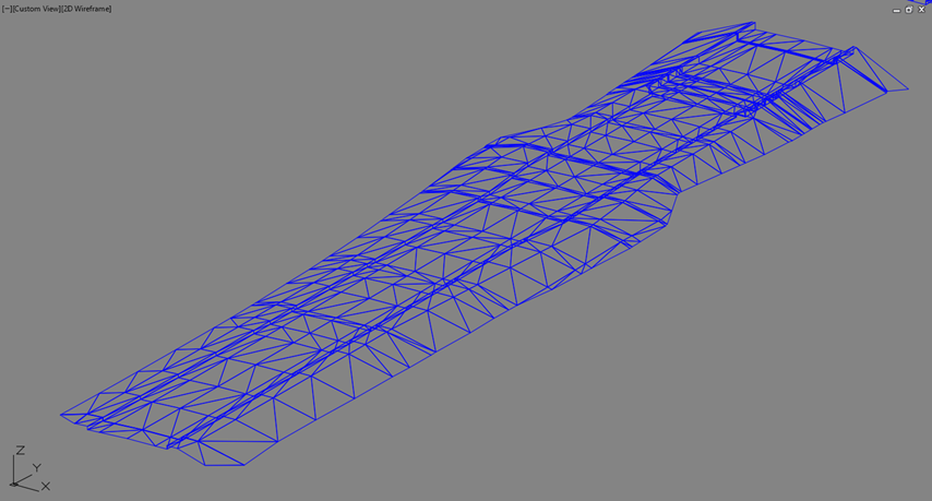
3D design surface models
-
Top & Datum surfaces
- 3D breaklines (*.dwg)
- Surface boundary (*.dwg)
-
DTM surface (*.xml)
-
Other deliverables
- Proposed Cross Section Data
- Earthwork Estimate Data (Average End Area)
- Sample Line locations for earthwork
- Right-of-Way Monumentation Data
Design to Construction Delivery Process
- Designer electronically submits CDP zip file with project PS&E documents
- Central Office (MDU) performs a data export check
-
CDP is posted on WisDOT website with plans and specifications
WisDOT Construction bid letting - General process overview (wisconsindot.gov)
Customization Supporting CDP Delivery
Custom Civil 3D subassemblies
- Updated .NET subassemblies using Subassembly Composer
- Provided full user control of subassembly point, link and shape codes
-
Enabled the targeting of horizontal and vertical objects
Repurposing Out-of-the-Box (OOTB) tools
-
Curb Ramps
- Used drainage structures “dynamic” staking points
-
Corridor Transitions
- Used numeric profile values as targeted transition data
Coding in C#
-
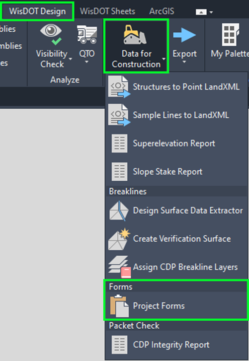
Export Tools Developed
- Structures to Point LandXML
- Sample Lines to LandXML
- Reports
- Design Surface Data Extractor
- Create Verification Surface
-
Assign CDP Breakline Layers
Key Take Aways
- Regular communication with contractors & stakeholders
- Create one powerful method
- Develop efficient workflows using OOTB tools
- Customization and repurpose OOTB tools to meet workflow needs
General Take Aways
- Be willing to adapt
- Collaborate and learn from others
- Leverage/Maximize your current technology
- Implement new technology
Thank you!
Resources:
-
WisDOT Facilities Development Manual > 15-5-7, 19-10-43
-
WisDOT Civil 3D Knowledge Base > Digital Data