Getting free LiDAR data into Civil 3D through InfraWorks
ACECWI Civil 3D workshop 2024
Last updated: 2026-01-06
What's this session about?
- There are questions and business needs that require elevation data to answer
- There's lots of surface data available
- There's some knowledge required to do the steps to acquire surface data
- You need to understand what uses the surface data is good for and what it's not good for
- I plan on keeping this fast and simple to the point that I think that this level of effort could be valuable on ANY Civil 3D/Infraworks project (the surface data version of Google Streets/Earth)
- The BIG advantage is that we will be bringing the data out of servers and webpages and into the software where you're doing work
LiDAR data
("what is it good for? absolutely nuthin'. uh-huh. uh-huh." War - Edwin Starr) Nope. Let's change that.
What it's not
- This is NOT a replacement for project-specific existing ground data collection efforts
- It is not currently accurate enough for hard-surface match-in elevations
- Any project-based collection efforts should remain in-place. Any requests of Central Office Survey and Mapping or regional survey data coordinators remain as-is
- No underground
- No vector-based data (points, survey figures)
What it is
- There are many times when surface data outside of normal existing surface data collection would help answer questions
- Time: Prior to project-specific collection effort
- Scoping
- Preliminary design
- Space: Area outside the physical footprint of the project
- Time: Prior to project-specific collection effort
- Common needs addressed with this data
- Drainage calculations
- 3D sight distance (intersection for instance)
- Slope checks (are those sideslopes 3:1 or 6:1?)
- Clearance checks (OSOW through existing roundabout)
- Visualizations (Next generation of roll plots for public meetings)
What you need to know before using ANY dataset
- When was it collected?
- Projection used?
- Critical because most data will not be in county projections and will need to be translated.
- How accurate?
- File format?
Software I will use
An Autodesk AEC Collections license will cover it
- Civil 3D 2024
- With current WisDOT package (WisDOT Civil 3D files (wisconsindot.gov))
- InfraWorks (It doesn't do a ton, but what it does, it does very well)
- Large datasets
- 3D display, navigation, working
- HINT: Data must have elevation to do anything in IWX
Datasets I will be working with
Our goal will be to get at least the following from the data:
- Surface data (XYZ)
-
Aerial imagery applied to that data (RGB)
I'm going to use 3 different datasets to show you the pros/cons they each have.
There is always a balance between file size, area, accuracy that must be considered against what problems you're trying to solve
- Autodesk InfraWorks Model Builder Help | Model Builder | Autodesk
- Built into software
- Based off
- Surface - USGS 10 meter DEMs from the National Elevation Dataset (NED)
- Imagery - Microsoft Bing Maps
- Also creates Roads, Railways, Water, Buildings
- A bit black box, sometimes more than you're looking for
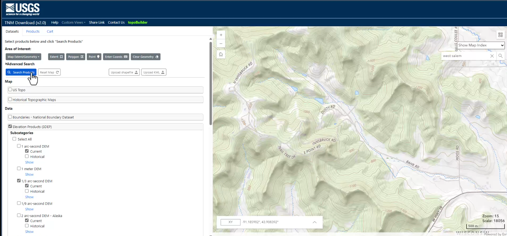
- USGS TNM Download v2 (nationalmap.gov)
- Surface (Elevation products)
- 1m available through most lower 48
- 1/3 arc second available everywhere (roughly 10m)
- GeoTIFF files
- Once zoomed into Area of Interest
- Check Elevation Products (3DEP)
- Click Search Products
- Click Download Link (TIF)
- Imagery
- NAIP Plus (1 meter to .5 foot)
- Available through EarthExplorer (requires login)
- For this presentation, I'm going to get the aerial data from GeoData
- Surface (Elevation products)
- Wisconsin GeoData GeoData@Wisconsin
- Surface and Imagery from county collection efforts
- Search terms (include county name to get specific)
- "LiDAR-Derived Tiled DEM" is individual tiles
- "LiDAR-Derived Countywide" is (you guessed it) whole county
- If you go this route, the projections are UTM and WTM (metric), but there are downloads for elevations in meters and in feet. You need to use the ones with all metric. InfraWorks can't have different units in horizontal versus elevation.
- I don't recommend this dataset due to the file sizes being HUGE.
- "Aerial Mosaic" is MrSID of the county
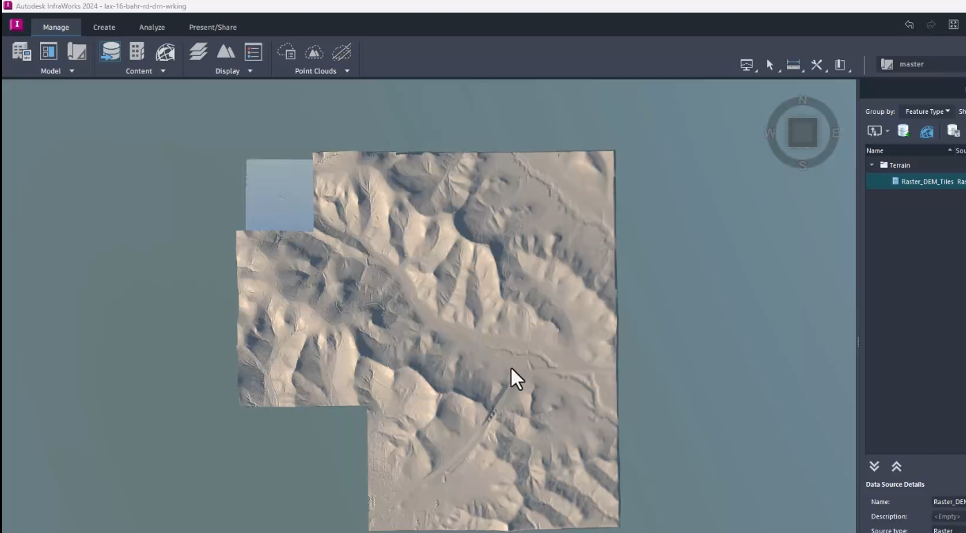
- Create InfraWorks project and add data
- InfraWorks > New...
- Set the coordinate system on creation. It will look like HARN/WI.CountyWI-F
- Manage tab > Content Panel > Data Sources
- Add file data source > Raster Data
- Add DEM file(s). If multiple are selected, IWX will merge them into a single surface
- Right-click Raster_DEM_Tiles > Configure to assign coordinate system
- USGS data will be Lat/Long (LL83)
- WROC data would be state plane (HARN/WI.WI-SF for example)
- Add file data source > Raster Data
- Add imagery file(s). If multiple are selected, IWX will merge them into a single surface
- Right-click LaCrosse_WROC_2020 > Configure to assign coordinate system
- Geo Location tab - WROC MrSIDs will be Wisconsin Transverse Mercator (WTM)
- Raster tab > Classification: Aerial, Clip to Model Extent
- Add file data source > Raster Data
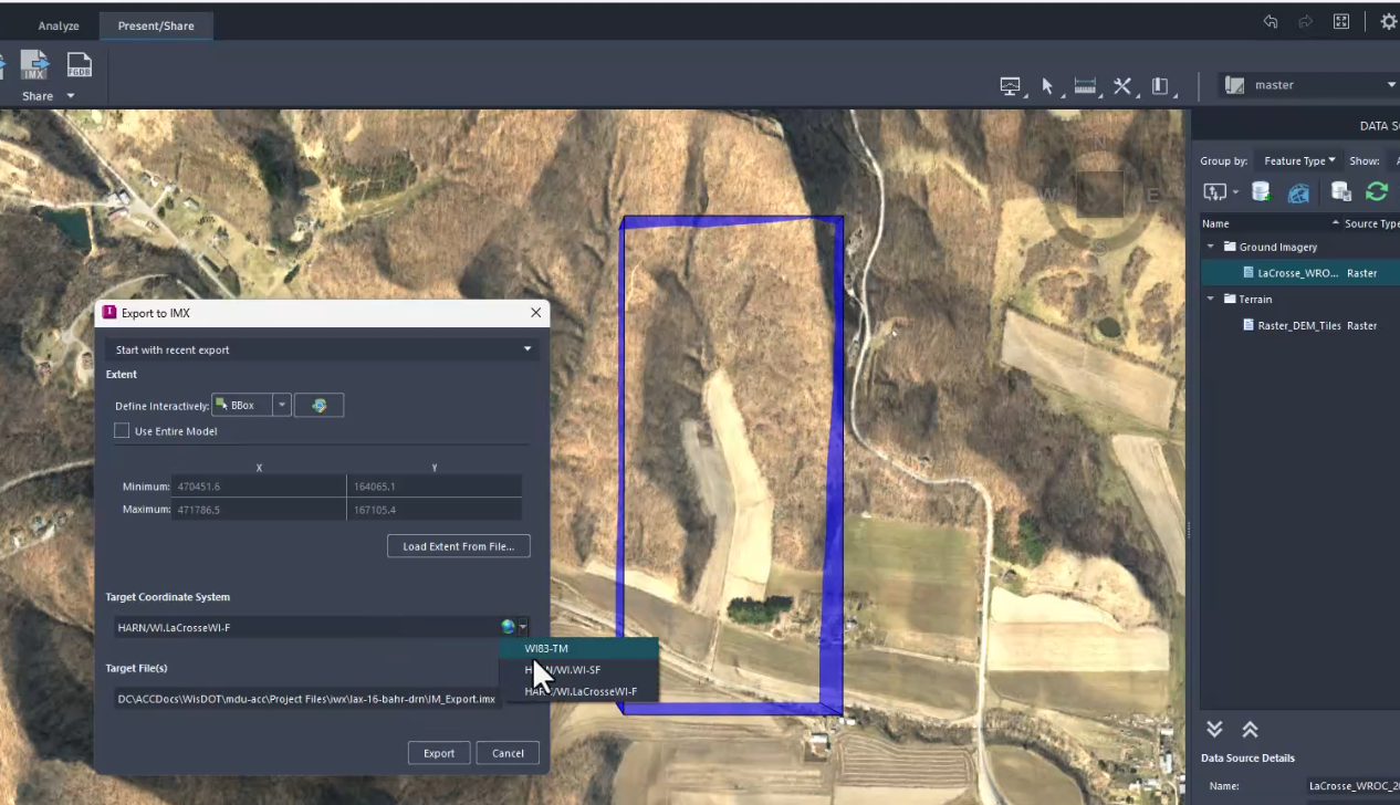
- Set home view - Upper right corner > down arrow > Set Current View as Home
- Export IMX file - Present/Share tab > Share panel > Export IMX
- Select only the area needed for hydro analysis. The smaller the file, the easier it will be for C3D to process
- InfraWorks > New...
-
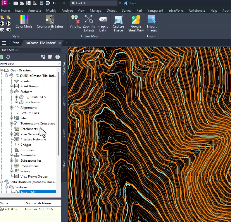
Create a surface in Civil 3D from IMX - InfraWorks tab > Import panel > Import IMX
-