Creating points from alignments
Last updated: 2026-01-06
Total video time: 08:21
Exercise files: pnt-frm-ali-data-begin-c3d20.zip
Creating points from alignments workflow
Home tab > Create Ground Data > Points dropdown > select Point Creation Tools
Start by setting automatic settings
- Open chevron
- Expand Points Creation
- Prompt For Elevations = Automatic
Prompt For Descriptions = Automatic - Object
Info: Object part will pick up name and station of the alignment for each point.
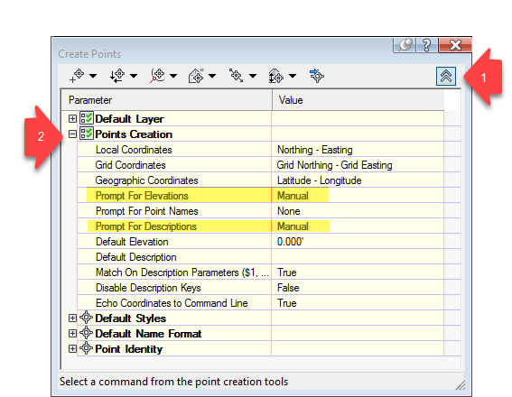
- Minimize to close Point Creation.
- Expand Point Identity
Next Point Number = 10000
Info: Allows you to identify proposed points easily
- Chevron to close.
Creating points from alignments
- Point by Alignment dropdown > At Geometry Points
- Select alignment: select the alignment
- Select a profile dialog box
: <none>
- OK
- Select a profile dialog box
: <none>
- Starting station: Enter to accept
- Ending station: Enter to accept
- Enter
- Select alignment: select the alignment
- Point by Alignment dropdown > Profile Geometry Points
- Select alignment: select the alignment
- Select a profile dialog box
: RiverRoad-CL
- OK
- Select a profile dialog box
: RiverRoad-CL
- Starting station: Enter to accept
- Ending station: Enter to accept
Enter
Info: If you don’t have the Elevation Description set to Automatic, you’ll need to put that information in for each point.
- Select alignment: select the alignment
- Point by Alignment dropdown > Measure Alignment
- Select alignment: select the alignment
- Select a profile dialog box
: <none>
- OK
- Select a profile dialog box
: <none>
- Starting station: Enter to accept
- Ending station: Enter to accept
- Specify an offset: 0.000Enter
- Enter an interval: 50Enter
- Enter
- Select alignment: select the alignment
- Close Create Points tools dialog.
Update new points to point groups
Toolspace > Prospector tab > right-click Point Groups > Update
Create a new point group
- Toolspace > Prosector tab > right-click Point Groups > New…
-
Point Group Properties dialog box
- Information tab
- Name: RiverRoad Align
- Default Styles:
- Point Style: Basic
Point Label Style: Pnt Number Raw Desc Elev
Info: Double-check these Styles. They may not be the default.
- Include tab
- With raw description matching (checked): RiverRoad*
- Select Point List tab to verify there are points there.
- OK
- Information tab
Verifying points are taking existing ground elevation, not proposed
- Toolspace > Prospector tab > Point Groups > right-click RiverRoad Align
- Toolspace Preview window
- Shift+A to select all points.
- Right-click > select Elevations from Surface
- Select surface : Exist
- OK
Export as *.csv, send out to the field
- Toolspace > Prospector tab > Point Groups > right-click RiverRoad Align > Export Points…
- Export Points dialog box
- Format dropdown: PNEZD (comma delimited)
- Destination File: browse folder
- Look in dropdown: project folder Other
- File Name: RiverRoad Align
- Files of Type: *.csv
- Open
- Limit to Points in Point Group (checked)
- OK