Export Civil 3D data to Google Earth, 3D
The WisDOT coordinate projection zone category which was in use through Civil 3D 2016 and 2018 has been retired and is no longer needed in Civil 3D 2020 and beyond.
Coordinate systems in Civil 3D should only be applied when a projection transformation is needed.
Projections for Civil 3D 2020 and beyond should be selected from the Zone Category: USA, Wisconsin. WISCRS projections begin with NSRS2011 Wisconsin County CRS
Projections for Civil 3D 2016 and 2018 should be selected from the Zone Category: WisDOT.
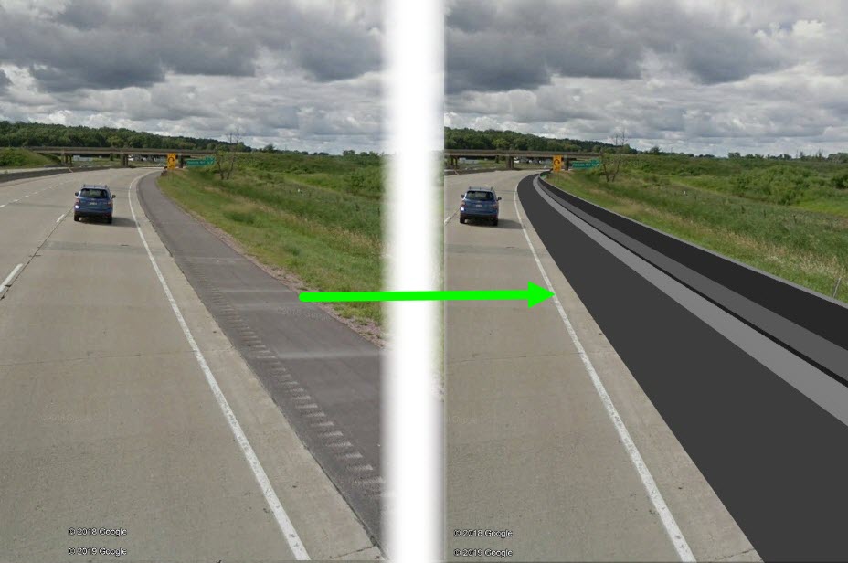
This workflow shows how to export Civil 3D surfaces to Google Earth. These files can be uploaded onto any device and show location in the field relative to the new surfaces. This can be a powerful communication tool.
If viewed on a mobile device on site, you can see your location with respect to the Terrain and the file.
This procedure works well with projects that are on grade or in a fill situation. Projects with significant cut will not give good results as surfaces below Terrain in Google Earth do not display. Adjustments can be made for shallow cuts to yield a good visual in Street View and Map View. These adjustments are covered in this topic.
Warning: Google Earth horizontal and vertical data is not as accurate as collected existing ground data and designs based on it. All users must understand this and make sure that people they communicate and share this data with understand the limitations on accuracy as well.
 Export Civil 3D file
- Open file > Save As a new file
- Assign Coordinate System
- App menu > Drawing Utilities > Drawing Settings > Units and Zones tab > Zone
- Categories: WisDOT
- Available coordinate systems: Appropriate county system in US Feet
- App menu > Drawing Utilities > Drawing Settings > Units and Zones tab > Zone
- Extract triangles
- Select surface > Right-click > Surface Properties... > Information tab
- Surface Style: Top Triangles
- Contextual ribbon > Surface Tools panel > Extract from Surface drop-down > Extract Objects
- Triangles: Select All
- Ok
- Select surface > Right-click > Surface Properties... > Information tab
- Change the color of triangles
Modelspace > Select the 3D faces to set color > Right-click > Properties...
- Color: Set to user preference
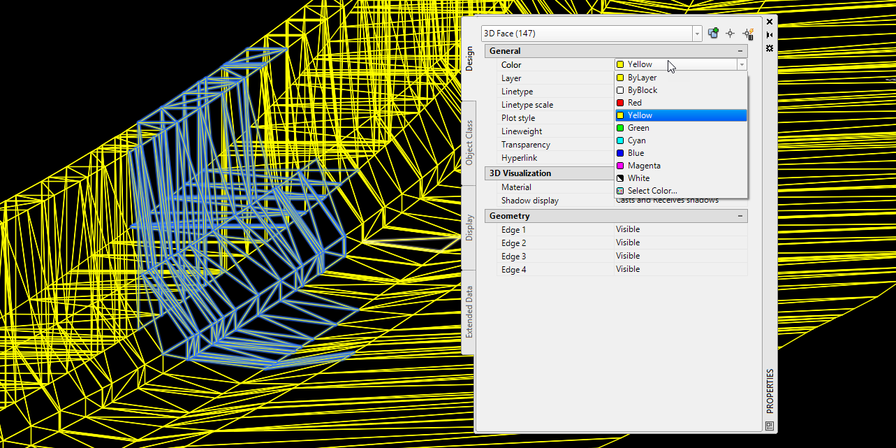
- Color: Set to user preference
- Export KMZ file
- Toolspace > Toolbox > Miscellaneous Utilities > Export KML > Export KML
- General > Name: Change name to the desired file name
- Objects
- Select all objects or manually chose by choosing the selected objects button
- Export text: checked
- Export object information: checked
- Geo-reference: Drawing Coordinate System Transform should be default selected
- Nudge
Elevation relative to sea level: checked
Nudging the surface up may be needed to see all of it. Google Earth elevations can be different than collected data and surfaces below the Terrain in Google Earth are not visible.
- Select location and name of file
- Export
- Export and view: View
- Toolspace > Toolbox > Miscellaneous Utilities > Export KML > Export KML
View the file in Google Earth (Desktop)
With Google Earth installed, open the file by double clicking on it
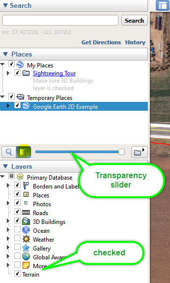
Under Places > My Places
- The files can be turned on/off by checking the box next to the file name
- The transparency can be adjusted by highlighting the file name and moving the slider
- Under layers, the Terrain box must be checked
Three common viewing issues and solutions
-
Model does not appear in Google Earth If the model does not show up at all with the Terrain box checked. Uncheck the box and see if the model displays in 2D. If it does and appears to be hovering around 100 FT from the surface, then this is likely a Civil 3D export issue.
Solution: Reassign coordinate system in Civil 3D and repeat export steps.
-
App menu > Drawing Utilities > Drawing Settings > Units and Zones tab
- Scale objects inserted from other drawings: checked
- Set AutoCAD variables to match: checked
-
-
Model in Street View is shifted horizontally When viewing the 3D model in street view, the model may look like it is not in the correct horizontal location.
Solution: In Civil 3D, translate the triangle faces a few feet by using a Move command then export the file again.
-
Model in Street View is shifted vertically When viewing the 3D model in street view, the model may look like it is not in the correct vertical location. Chances are that the elevations from Google Earth and the model elevations are not identical. Google Earth has a feature for vertical scaling to help make the drawings align. Note: Google Earth layers are locked. In cut locations it may be difficult to get a desired visual.
Solution: Scale in Google Earth
- Google Earth > Tools menu > Options...
- Modify the Elevation Exaggeration (default = 1). A value less than 1 will have the effect of raising the Civil 3D model.
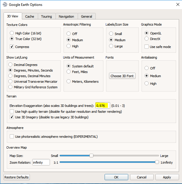
- Modify the Elevation Exaggeration (default = 1). A value less than 1 will have the effect of raising the Civil 3D model.
- Google Earth > Tools menu > Options...